Katie HOLten: Drawn to the edge, NEW ORLEANS MUSEUM OF ART, NEW ORLEANS, USA
May 11 - September 9, 2012
For her Great Hall exhibition called “Drawn to the Edge” Holten created a series of large-scale drawings addressing her interest in the ever-evolving boundaries or “edges” between land and water. Having spent six weeks in New Orleans as part of A Studio in The Woods residency in early 2012, Holten’s drawings reflect her research on the Mississippi River and the wetlands along the southern coast of Louisiana. Tracing shifting paths of sediment, Holten’s drawings outline paths of water in a map-like fashion, while at the same time acknowledging the shifting nature of these maps due to climate change and land management decisions. The drawings are suspended from the ceiling of the Great Hall, manifesting Holten’s desire to translate two-dimensional drawings into a kind of three-dimensional sculpture. Holten is working with authors Rebecca Snedeker and Rebecca Solnit on drawings for their atlas project titled Unfathomable City: A New Orleans Atlas. Holten looks to Solnit and Snedeker’s concept that “Places are leaky containers…Something is always coming from elsewhere, whether it’s wind, water, immigrants, trade goods, or ideas… Every place deserves an atlas.”
More info on the New Orleans Museum of Art website.
![Cloud(s) over Cocodrie Bay (as seen from Google Maps), [verso], 2012, graphite, charcoal, and cosmic turquoise acrylic on canvas, 10 x 12 feet.](https://images.squarespace-cdn.com/content/v1/587fa7ec46c3c40b37346157/1493929355279-W1RQPUWHK9JXZ3W0V4TM/NOMA.cloud.jpg)
Cloud(s) over Cocodrie Bay (as seen from Google Maps), [verso], 2012, graphite, charcoal, and cosmic turquoise acrylic on canvas, 10 x 12 feet.

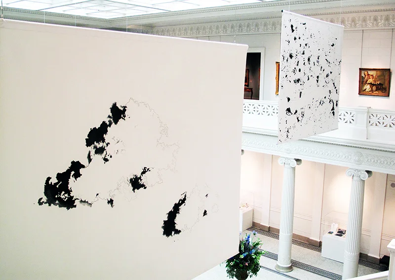
Installation view.
![Cloud(s) over Cocodrie Bay (as seen from Google Maps), [recto], 2012, graphite and charcoal on primed canvas, 10 x 12 feet.](https://images.squarespace-cdn.com/content/v1/587fa7ec46c3c40b37346157/1493929359043-V6J8MMXVLAOZT29DVSGG/NOMA.Clouds.jpg)
Cloud(s) over Cocodrie Bay (as seen from Google Maps), [recto], 2012, graphite and charcoal on primed canvas, 10 x 12 feet.
![Constellations (map of Louisiana oil and gas wells), [recto], white charcoal and chalk formed during the Cretaceous era and collected from the former ocean floor of the Inland ocean in Kansas on black primed canvas, 2012, 10 x 12 feet.](https://images.squarespace-cdn.com/content/v1/587fa7ec46c3c40b37346157/1496664223696-1URZ7G0ATIZQXXVGYAGT/NOMA)
Constellations (map of Louisiana oil and gas wells), [recto], white charcoal and chalk formed during the Cretaceous era and collected from the former ocean floor of the Inland ocean in Kansas on black primed canvas, 2012, 10 x 12 feet.
Installation view of the recto sides of from left: Cloud(s) over Cocodrie Bay (as seen from Google Maps) and Constellations (map of Louisiana oil and gas wells), 2012, 10 x 12 feet (each).
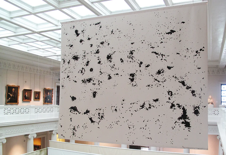
Constellations, (recto), 2012, graphite and charcoal on canvas, 10 x 12 feet.
![Detail: Found Island (Creole Bay / Pine Island), [verso], 2012, graphite and charcoal on raw canvas, 12 x 36 feet.](https://images.squarespace-cdn.com/content/v1/587fa7ec46c3c40b37346157/1493929379325-TO22LEDLWHSYAP1O8FCL/NOMA.island.detail.jpg)
Detail: Found Island (Creole Bay / Pine Island), [verso], 2012, graphite and charcoal on raw canvas, 12 x 36 feet.
![Installation view: Found Island (Creole Bay / Pine Island), [recto], 2012, graphite and sediment collected from the Mississippi River and acrylic gel medium on primed canvas, 12 x 36 feet.](https://images.squarespace-cdn.com/content/v1/587fa7ec46c3c40b37346157/1493929385126-NOK5FBM94JFZGAAL55KC/NOMA.view.island.jpg)
Installation view: Found Island (Creole Bay / Pine Island), [recto], 2012, graphite and sediment collected from the Mississippi River and acrylic gel medium on primed canvas, 12 x 36 feet.

Detail: From the Collection, mixed media in display case, 2012.
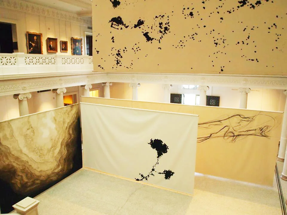
Installation view.

Installation view.